Add details about accommodation and sites in Ainaro
Ainaro District
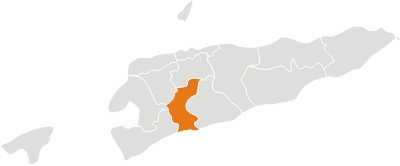
Located in the southwest part of the country. It has a population of 59.175 inhabitants (Census 2010) and an area of 797 km². The capital of the district is also named Ainaro. Ainaro district is identical to that of the same in Portuguese Timor, with the following exceptions: during the Indonesian administration, the subdistrict of Turiscai became part of Manufahi, while the subdistrict of Hatudo became part of Ainaro in exchange. Ainaro district comprises today the subdistricts of Ainaro, Hatudo, Hatu Builico and Maubisse. Ainaro has a great abundance of rivers and fertile soil for agriculture. It has a coastal area on the south part of the island, but also mountain ranges, such as the Mount Ramelau (2.960 m) which forms the highest peak in the country. Ainaro played an important role during the Resistance period due to its topographic features which provided shelter for the guerrilla. In addition to the official languages of the country (Tetun and Portuguese), the majority of the population speaks Mambai.


